“The trail puts a hook in you.  You never feel it happening, and you don’t know exactly when the hook gets set.  But set it is, hard.  And you can’t shake it.  You don’t want to shake it.  You just want to get back to it.  It’s like a hole in you yearning to be filled once you are gone and back to civilization.  It’s what you think about for weeks.  No matter how hard the trek was, no matter what you endured, no matter how many times during the trek you swore you were done, cured and over it, you’re not.  You never will be.  It’s in your head forever.

It can’t really be explained to someone that hasn’t experienced it.  It isn’t the hiking, the camaraderie, the physical exertion, the rush, the fear, the anxiety, the views, the space, or the air.  It’s all of that, and none of that, and more.  To those that have experienced it, they know exactly, without explanation, what you feel.  They feel it too, and can’t explain it any better than you can.  It’s why they’re going back just like you are.  One last time you say, and you know it’s a lie when you say it.”

                                                                  Keith Lamparter

This summer we made our second backpacking trip to Wyoming’s Wind River Mountain Range.  On Monday, Aug. 14, 2017 our party of 5 departed the Trail Lakes Trailhead outside of Dubois, WY for 8-days in the wilderness.  Our team consisted of Melissa Berger, Dan Lamparter, Ashley Martinez and Shawn Palaszewski, all 28, and myself, age 59.  We hiked nearly 80 miles, visited many of the crown jewels of the “Winds”, and explored some of its most inaccessible places.  Only 4 of the 8 days were spent on-trail, with the balance spent freelancing and route-finding through incredibly rugged and isolated stretches of wilderness where we went days without seeing another human being.  We crossed four significant passes, reached 12,200 ft. above sea level twice, transited Knifepoint glacier at 11.500 ft., and crossed more streams, creeks, rivers, snow-fields, rock-fields and marshes than we can count.  On our final day we witnessed the total solar eclipse from within the area of totality.

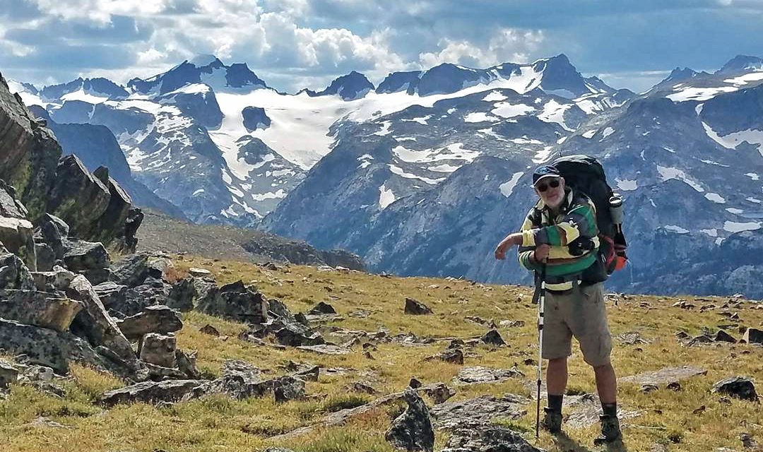
Gannett Peak, Wyoming’s highest peak at 13,804 Ft., viewed from the Ink Wells Trail.

In our book documenting last year’s hike, we had a picture from this exact spot. But someone else took it.  This year it is our picture. We took it. We did it.  We were there.  We lived the dream.  The Dinwoody, Gannett Peak, the Ink Wells, Horse Ridge, both Indian Passes, Knifepoint Glacier, Titcomb Basin and Glacier Panorama.  All the places I have read about and dreamed of seeing for 14 years.  The greatest satisfaction is knowing you are good enough.  And this year we were. We made mistakes and learned lessons on things we would do better, or differently.  But these treks are a pass-fail test.  You either make it and finish or you don’t.  This year we passed.  And we will never forget this one.  We had a great team.  Melissa was a trooper with a bad wheel who took everything in stride and showed again she can handle anything, including overcoming her fears.  Dan from Hollywood surprised us all with how well he adapted to the wilderness and his strength as a hiker.  He made me proud.  Ashley never complained, proved to be a strong hiker and was a stabilizing force to the team.  And Shawn was a powerful hiker that led the way most days and kept us all entertained with an endless stream of stories.  I am proud of all of them and privileged to have shared this experience with them. Our video below compiles the best pictures of our hike in a day-by-day format.  Following that is my log for each day.
Introduction and Back Story

Melissa watching the solar eclipse at Hobbs Lake.

Our trek this year has some history behind it for anyone who happens to be reading this.  It begins in 2004, after I had finished living in Jackson Hole and returned home to Arizona.  I bought a book by Ron Adkison called “Hiking Wyoming’s Wind River Range”.  It detailed all of the well known trails and routes of the Wind River Range.  I read about each trail, marveled at the pictures, and dreamed about seeing those places for myself. One of those trails was the Glacier Trail, and it became the one place I wanted to see more than any other.  The very first sentence of that chapter put the hook in me, “The Glacier Trail, one of the classic high trails in the Wind Rivers, is an epic journey with no rivals in the Rocky Mountains.“ But for 13 years there were no takers to make the trip with me.  Last year, 2016, my daughter Melissa Berger told me she was ready to try it.  But we decided that two first-timers would be better off picking a route more suited to our limited experience, so we did a 7-day, 40-mile loop from Big Sandy Trailhead instead.  At the end we were both hooked and started planning for 2017.  My desire to hike the Glacier Trail was still there, and I posted this at the end of last year’s book documenting that trip: “We enjoyed our trip so much we are already planning next year’s trip.  Above is one of our planned destinations, Dinwoody Creek and 13,804 foot Gannett Peak.  This is the site of the largest concentration of glaciers in the lower 48 states and one of our goals is to traverse Dinwoody and Knifepoint Glaciers on our journey…” Melissa had one demand for this year, to visit Titcomb Basin.  Fitting Titcomb and all the places I wanted to visit into 8 days proved difficult.  I showed Melissa my first route option at Thanksgiving 2016.  It would not take us on the Glacier Trail or to Gannett Peak, but it was a loaded 8-day trip of 65 miles.  It would take us into Dry Creek Basin from the Wind River Indian Reservation to the east, then up Horse Ridge to 13,500 ft. Mt. Febbas, back to dry Creek Basin, over both Indian Passes and Knifepoint Glacier, stopping at Titcomb Basin and exiting Elkhart Park Trailhead.  The look on her face told me everything I needed to know. It was too extreme and I needed to scale things back. So I gave up on Mt. Febbas and reaching 13,500 ft., added rest days, and changed our exit to the more scenic Green River Lakes. I was disappointed giving up on 13,500 ft., but I knew this was a better plan.  Melissa blessed the new route with one option, she wanted more people because we would be in grizzly territory this year.  AND, she wanted us to be in the Winds for the total solar eclipse that was to pass directly overhead on August 21.  So with that in mind we began our preparations and began the recruiting process, which resulted in Dan Lamparter, Ashley Martinez and Shawn Palaszewski joining us on this year’s trek. Of course, nothing ever works out as planned. Because of the eclipse and rescheduled hikes due to the late melt-out of heavy snow this past winter, the outfitter you must use to go into Cold Springs Trailhead told me they didn’t have room for all of us on the day we requested.  We could either go in the day before or two days later.  But all the hotel rooms in the area had been booked months in advance and I couldn’t change our reservations.  So we either stuck to our dates and changed our route or made our trip longer or shorter as I would not give up on a hot shower and a bed after 8 days in the wilderness.  If we chose to stick to our dates the only viable route option was to hike in on the Glacier Trail and summit over Horse Ridge.  Which both thrilled me and scared me at the same time.  It added 10 miles to the trek and meant we would be hiking every day for 8 days with no rest even if the weather turned bad.  The first day would be 9-10 miles and a 3,000 vertical ft. elevation gain.  Day 3 would be another long day and another long climb of 2,800 vertical ft. to 12,200 ft. I am the oldest of our team at 59, the rest are 28, and I knew this would test me to my limits.  But I also knew this would probably be my last shot at the Glacier Trail and Horse Ridge and all the other places on the hike.  So I put it out to the team and, in the end, work and school schedules decided things and the vote came in to go with the new route and stick with our original dates. So we were set. I would finally see the Glacier Trail, the Ink Wells, Gannett Peak and hike over Horse Ridge. All those places I had dreamed about seeing for 14 years.  I must confess here that there were multiple times on this trip where I was convinced that I had reached my limits and made a mistake taking us on this route.  I surprised myself being able to achieve what we did on Day 1.  More surprised I was able to get up and do it again Day 2.  Day 3 taxed me beyond what I thought I could do and it was on this day I told myself I was done with these treks.  I dreaded Day 5 and the climb of Knifepoint Glacier for days, and while we were on the glacier I worried about everyone on our team and what I had gotten them into and literally screamed with relief when it was over.  And now I want to start planning for next year.
Overall Route Map and Description
This year’s trek takes us 77.8 miles, from the Trail Lake Trailhead (formerly Torrey Creek TH) in the Fitzpatrick Wilderness to the Elkhart Park Trailhead in the Bridger Wilderness on the opposite side of the Continental Divide.  We followed the Glacier Trail south for two days to its connection to the Ink Wells Trail, crossing Arrow Pass at 10,896 ft. on Day 1.  We then followed the Ink Wells Trail to Horse Ridge traveling off-trail to 12,200 ft., then descending into Dry Creek Basin.  At Dry Creek Basin we turned west and followed the trail to Don’s Lake, then off-trail again to East Indian Pass.  From the 11,543 ft. summit of E. Indian Pass we descended 800 ft. and headed north to the headwaters of the North Fork of Bull Lake Creek (“NFBLC”) at the base of Helen Glacier, surrounded by Mt. Helen, Mt. Warren, Turret Peak and Mt. Febbas, all in excess of 13,500 ft.  We then cross Panorama Pass at 11,060 ft. and began our ascent up Knifepoint Creek to Knifepoint Glacier and Indian Pass.  We crossed Knifepoint Glacier at 11,500 ft. and Indian Pass at 12,135 ft., crossing the Continental Divide and moving from the Fitzpatrick Wilderness to the Bridger Wilderness.  We crossed Indian Basin on the Indian Basin Trail, took a detour into Titcomb Basin, and then continued southwest on the Highline Trail, Seneca Lake Trail and finally the Pole Creek trail to our exit at Elkhart Park Trailhead.  Although we exited Elkhart Park instead of Green River Lakes as we had planned, we exceeded our planned mileage of 75.2 miles by 2.6 miles.

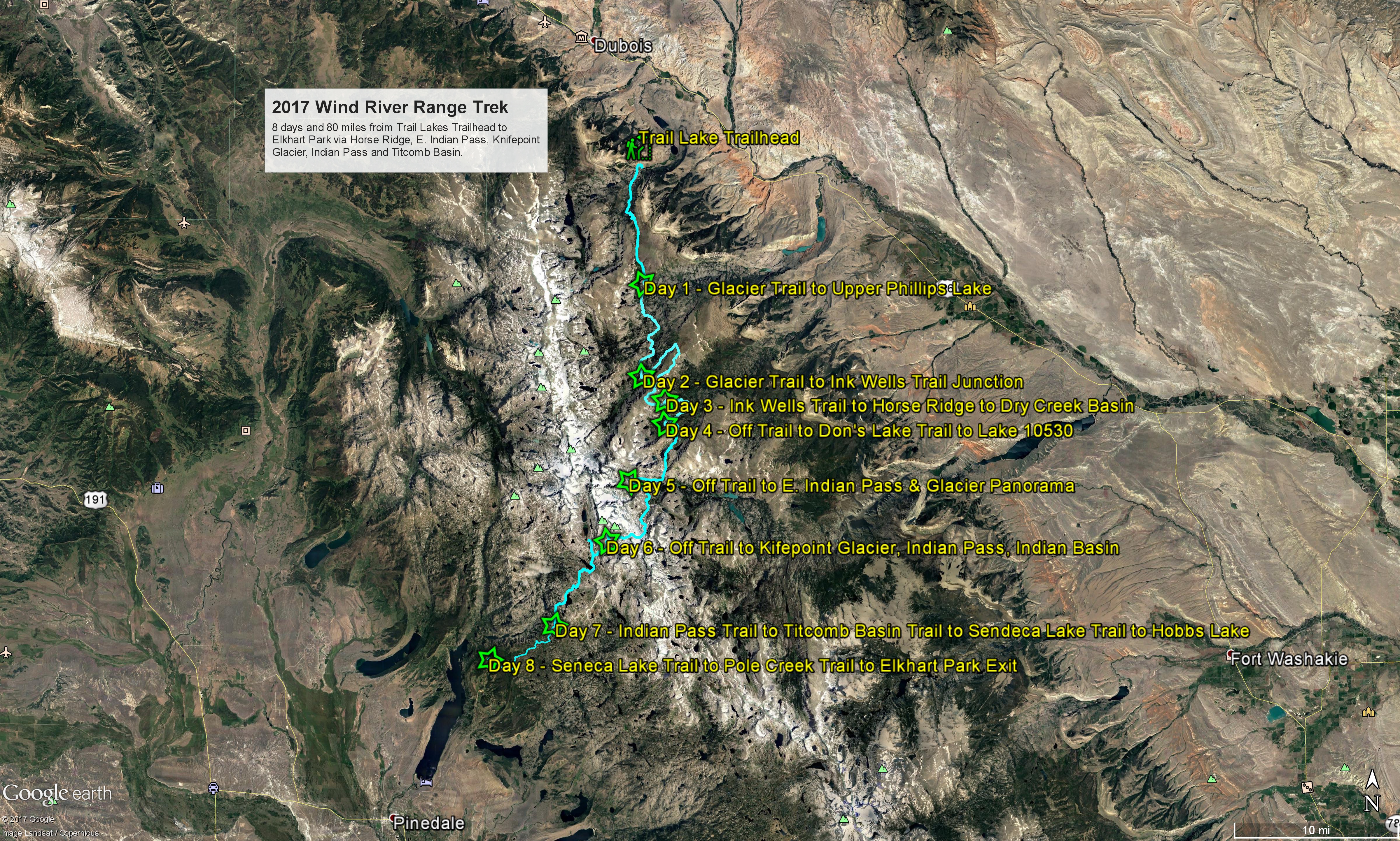
Google Earth route of our trek.

Day 1 - Torrey Creek Trailhead to Upper Phillips Lake

Monday, August 14, 2017 Total Miles:11.42 Time on Trail: 11 h 54 m Beg. Elev.: 7,566 End Elev.: 10.115 Min. Elev.: 7,523 Max Elevation: 10,896

Climbing up to Torrey Creek from the Trailhead.

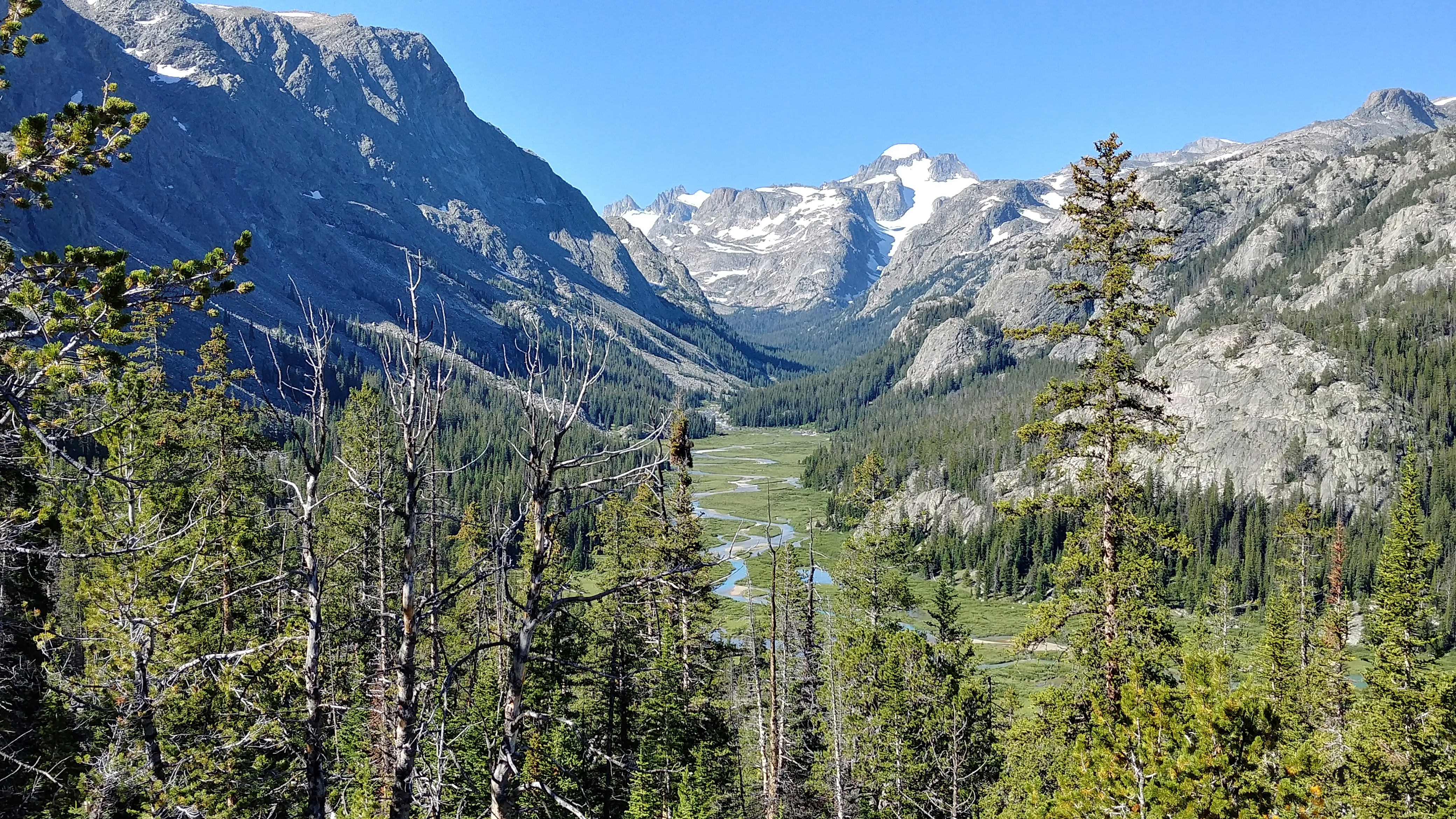
Our day begins early at the Twin Pines Lodge in Dubois.  We had fun the night before at the Outlaw Saloon playing pool, drinking and meeting the locals.  But today we are up at 5 am and on the road by 6.  It’s about a 1/2 hour drive to the trailhead. We are on the trail by 7:30.  The day is cloudy and cool.  We take the Glacier Trail, which begins with an immediate climb up the hill to Torrey Creek.  We cross Torrey Creek on a nice bridge where the creek comes down a very narrow gorge in the rocks.  From there we begin a slow, gradual climb over rocky terrain.  After a few miles the trail crosses large meadows alongside Torrey Creek.  We have a nice view into Bomber Basin, so called because a B-24 bomber crashed here in 1943. At about 3-1/2 to 4 miles in we begin a long series of steep switchbacks that take us to the high plateau that leads to Arrow Pass.  I am not struggling as much as I did last year, the lighter pack and better conditioning I suspect, but the climb is still difficult and long.

At about the 7-mile mark we reach the top of the switchbacks and I notice that the distances listed in the trail guides and on Google Earth are not matching the distances my phone’s GPS app is recording. Each way-point we have reached is further than the calculated distances according to my phone app.  At this point we have hiked a mile further to reach this point than either the guides or Google Earth calculated.  Although we have reached the plateau the climb up continues and it has taken us longer to reach this point than we planned.

We are nearing Williamson Corrals and decide to stop in a grove of pines along the creek for lunch.  Shawn drops his canister of bear spray and the cap pops off.  He is using his knife to get the cap back on when the canister discharges hitting him in the face with pepper spray.  At first we don’t understand what has happened, but quickly realize we might be in a very bad situation.  Shawn buries his head in the cold water of the creek to wash out his eyes and face for the next ½-hour. The pain was intense and he was shaking visibly. The fact that he was able to not only endure it but continue on with the day’s hike is a tribute to his ability to withstand pain.

Back on the trail after a long delay, we have a long way to go to tonight’s planned camp at Double Lake.  We pass Williamson Corrals where an outfitter has let his horses loose to feed in the grass.  The trail is wet from the rain yesterday and for the past two weeks, and the horses of the outfitters have pounded much of the trail into a muddy mess making it even slower going that it would be normally.  We finally reach Arrow Pass, having climbed 3,330 vertical feet from the trailhead, and begin our downward descent.  We cross a long expanse of open country, marshy, wet and muddy.  After a mile or more of this open country the trail now takes us down into a forest of burned pine trees.  Wildflowers are thick here as we descend towards Phillips Lake.  It has not rained today but the sky is getting darker and the clouds thicker.  Our day’s plan called for us to reach Double Lake after 10 miles of hiking, but we have already hiked over 11 miles to this point and there is still a mile or more to Double Lake.  So we decide to call it a day on the outflow creek from Phillips Lake.  Mosquitoes here are horrible and are coming after us in literal clouds of bugs.  We are putting the mosquito repellent to good use and it seems to work quite well.

Shawn starts a fire, Dan and I set up tents and Melissa and Ashley and Shawn begin getting our meals ready.  Melissa and I make some hot coffee and add some of the whiskey we brought with us to it. That hits the spot.  Everyone seems to be having a good time, and is figuring out their roles and the routine of unpacking and organizing and how everything works.  After dinner and hanging our food containers in a tree, we call it a night early. Everyone is beat.

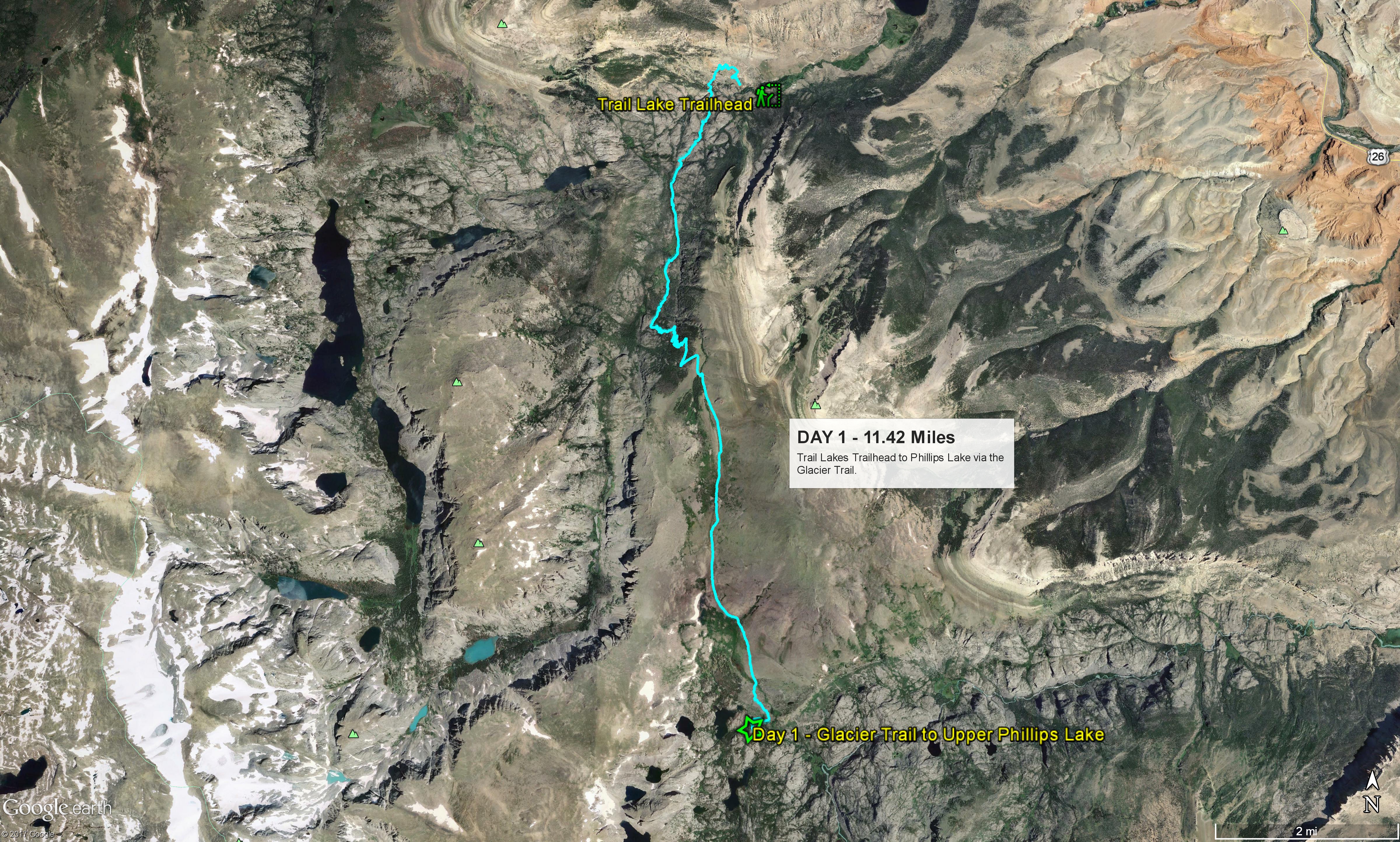
Google Earth route of Day 1.

Day 2 - Upper Phillips Lake to the Glacier Trail-Ink Wells Trail Junction

Tuesday, August 15, 2017 Total Miles:10.13 Time on Trail: 8 h 9 m Beg. Elev.: 10,115 End Elev.: 9,554 Min. Elev.: 9,150 Max Elevation: 10,335

Bridge across the Downs Fork on the Glacier Trail.

It rained most of the night but had stopped by morning.  Everyone’s boots had gotten quite wet yesterday and they were still wet this morning.  A number of trekkers have walked by our camp this morning on the way down the trail back to the trailhead.  Several groups looked to be climbers that had attempted Gannett Peak.  By the time we got things generally dried out, packed up, pictures taken and on the trail it was after 9:15 am. The trail started out slowly, descending to Double Lake which is where we had hoped to spend the previous night.  The pictures don’t do it justice.  It is a special jewel, quite beautiful.  From there we started climbing gain until we reached our maximum elevation for the day above Honeymoon Lake.  We follow a series of steep switchbacks down and then we follow Honeymoon Creek down the canyon shedding all of the elevation gained to this point until we reach some beautiful falls on Dinwoody Creek, which is actually a raging river. The Downs Fork and the Dinwoody have merged here and the amount and volume of water takes us by surprise.  A storm blows up quickly and we don our rain gear.  A steady rain falls and then turns into hail before ending as quickly as it started.  We are steadily gaining elevation again as we traverse through forests and then along large alpine meadows that are extremely swampy and wet as we follow Downs Fork Creek.  We have to make way twice for outfitters with horses and mules that are beating the trail into a muddy mess.  In some places the trail has become a trench over a foot deep filled with water and mud and we have to pick our way along the edges.  Although the ground is generally flat the hiking is tedious and slow as we are forced to constantly rock-hop and search for dry places to put our feet alongside the trail. We reach a nice bridge across the Downs Fork and stop to rest.  The water here is turquoise blue and absolutely ice cold.  I pull my boots and socks off and try soaking my feet but the water is so cold it is painful.  Melissa has a very large, nasty blister popping up on her heal from wet socks.  I bandage that and she changes into some dry socks.  Ashley also has a small blister on her foot.  We meet a nice man and his dog on the bridge.  He is from Kansas City and has been high up on the Downs Fork in very remote country.  He tells us we are the first people he has seen in 3 days.  Soon after leaving the bridge we have to ford the creek again on fallen logs, and Melissa loses her footing and steps into the cold creek.  So much for her bandage and dry socks. From the Downs Fork we begin following the Dinwoody again.  More large alpine meadows, very wet and swampy, lots of mosquitoes and a wet muddy trail.  We are forced to don our rain gear again as another storm with rain and hail comes up on us.  We have been steadily gaining some elevation back for the past several hours. When we reach the Glacier Trail-Ink Wells Trail junction we cross a small bridge across the Dinwoody and another large storm is bearing down on us.  As with yesterday, we had hoped to reach another camp further along the trail but we have already put in our planned 10 miles for the day and the weather is turning bad on us.  We don’t have much time to pick our spots so we throw our tents up just outside the outfitter camp on some grassy, dry ground. The rain hits hard before our tents are all the way up. After the rain passes Melissa talks to one of the wranglers from the outfitter camp who invites her down to their camp later. Just before dark some Navy Seals that are at the outfitter camp come down to our tents and invite us for drinks and a campfire.  I know they are there because with have two cute girls on our team so Dan and I stay in our camp and rest.  Shawn, Melissa and Ashely take them up on their offer.  I believe a good time was had by all.

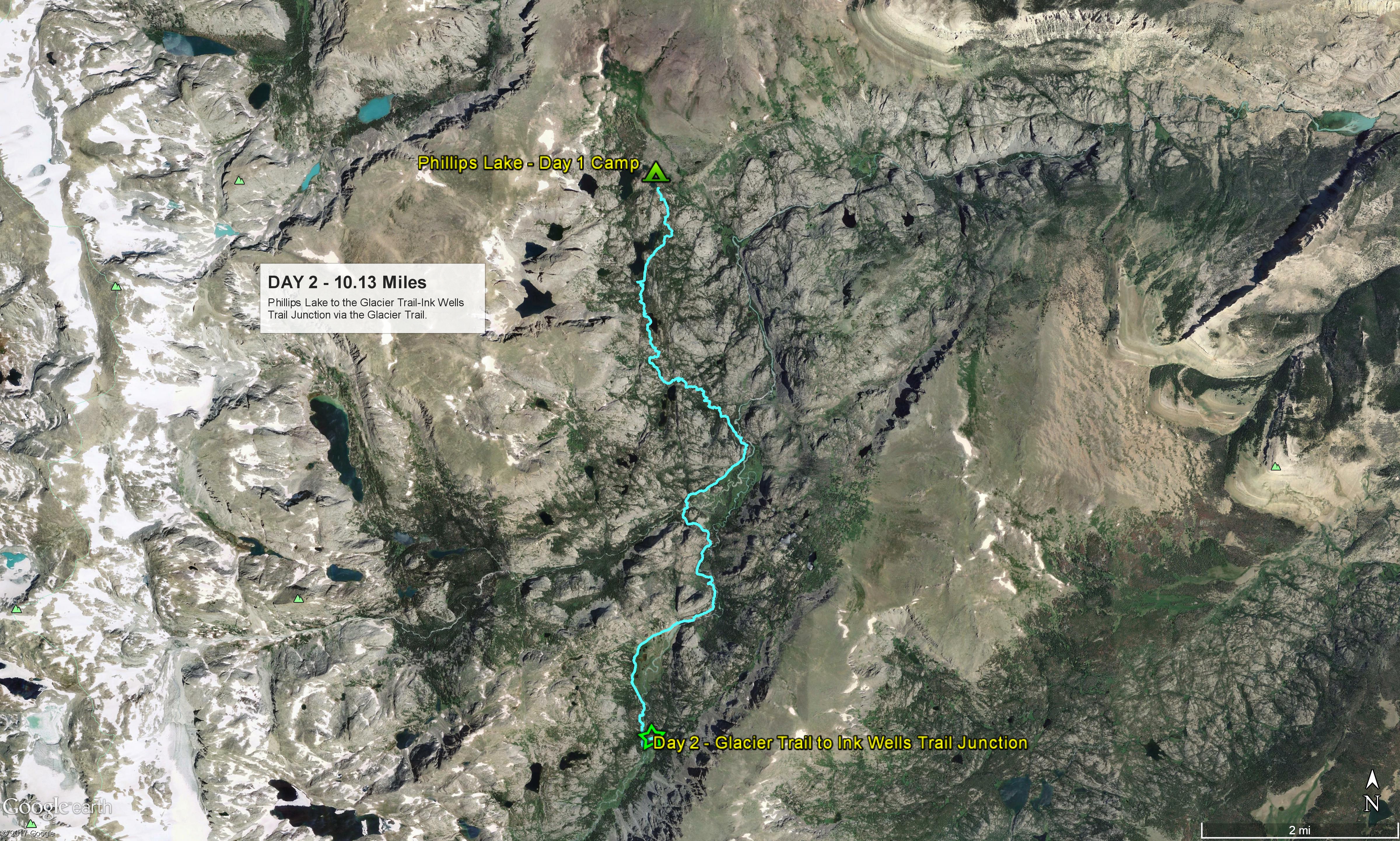
Google Earth route of Day 2.

Day 3 - Glacier Trail-Ink Wells Trail Junction to Lake 11060 in Dry Creek Drainage

Wednesday, August 16, 2017 Total Miles:11.16 Time on Trail: 10 h 21 m Beg. Elev.: 9,554 End Elev.: 11,060 Min. Elev.: 9,554 Max Elevation: 12,178

Melissa and Ashley at 12,000 ft. Gannett Peak and Gannett Glacier behind.

The outfitters had turned out their herd of horses and mules to feed in the meadow last night so we woke up very early to the sounds of hoofs and the bells on the mule’s necks as the herd made its way back to their corral at daylight.  When we crawled out of our tents there was a layer of ice on our tents and gear and the grass was coated in a hard frost.  With the mountains behind us to the east the sun did not shine on us directly until late in the morning.  The good news was the cold seemed to have put the mosquitoes into hibernation and we weren’t bothered at all for the first time this trip. Once we were packed and on the trail we started climbing immediately and I don’t think we stopped climbing for the next 9 hours.  I knew this was going to be a hard day, but I honestly was not prepared for what we encountered and had to endure this day. We started by following the Ink Wells Trail east into some very pretty country.  Some of the locals in Dubois had told us this was a very pretty stretch and one guy had shown us arrowheads and tools he had collected.  Evidently this area was part of a very large, high altitude American Indian community thousands of years ago.  It was indeed gorgeous.  We had originally hoped to get a few miles further up the trail yesterday for camp so that was strike one against us today.  Then, the route up Horse Ridge that I had planned on using looked much steeper and rockier than I had been led to believe so we opted to go further up the Ink Wells Trail for an easier access point.  These two items added several extra miles to our day which translated to several extra hours on the trail.  Once we reached our access point to Horse Ridge we left the Ink Wells trail and headed west.  We would be off-trail for the next 4 days. The initial route up Horse Ridge was very much what I had imagined, a very long, steep climb up grass and rock covered slopes.  We reached an overlook into Dry Creek Basin where we could see many lakes below and Cold Springs Trailhead in the distance to the east.  From there we continued to climb, and climb and climb for the rest of the afternoon.  The ridge became increasingly rocky and areas that showed as relatively flat or level on the topo maps were in reality boulder piles and rock strewn ridges that forced us to alter our intended route.  We also encountered a great deal of snow from this past winter that we had to detour around.  The mileage to this point was much longer and our progress much slower than planned.  As a result we found ourselves exposed on the ridge at high altitude much later into the afternoon than we had planned.  I was worried about a storm blowing up while we were exposed like this but the gods smiled on us this day.  Storm clouds came in from the west, it got colder and darker, but thankfully no rain as the clouds drifted off to the east. The girls spotted a small herd of elk while we were high up on Horse Ridge but the herd ran as soon as we saw them and disappeared.  Elk and bighorn sheep droppings are everywhere on the ridge.  We finally reached 12,200 feet which marked the summit point for us where we could begin our descent.  But once again the route was much rockier that we had planned on.  We also ran out of water before reaching our summit point.  Fortunately, yesterday’s rain storms had left fresh pools of water in the rocky depressions for us.  We slowly picked our way down the ridge, unsure of the correct path to take, until we reached our intended exit point down into the valley below.  But there we found our path once again blocked by snow banks.  So once again we began altering our route looking for ways around and down to the bottom. Today was supposed to be 7.1 miles of hiking but we had already done 10 miles to this point.  We were all extremely tired, and it was clear we would not be able to reach our intended camp at Don’s or Cub Lakes for the night.  So we searched out an alternate location to spend the night.  We found a very pretty lake at 11,060 ft. where we called it a day and pitched camp. Bighorn sheep and elk droppings were everywhere on the ground.  We ended up doing 11.16 miles for the day. The views and scenery were spectacular.  Better than I think anyone had imagined.  But the effort was much greater than we had planned.  I was absolutely dead tired and, once camp was set up, I crawled into my sleeping bag, too tired to even eat.  

Google Earth Route of Day 3.

Day 4 - Lake at 11060 Below Horse Ridge in Dry Creek Drainage to Lake 10530 West of Don's Lake

Thursday, August 17 2017 Total Miles: 5.81 Time on Trail: 4 h 8 m Beg. Elev.: 11,060 End Elev.: 10,530 Min. Elev.: 9,911 Max Elevation: 11,112

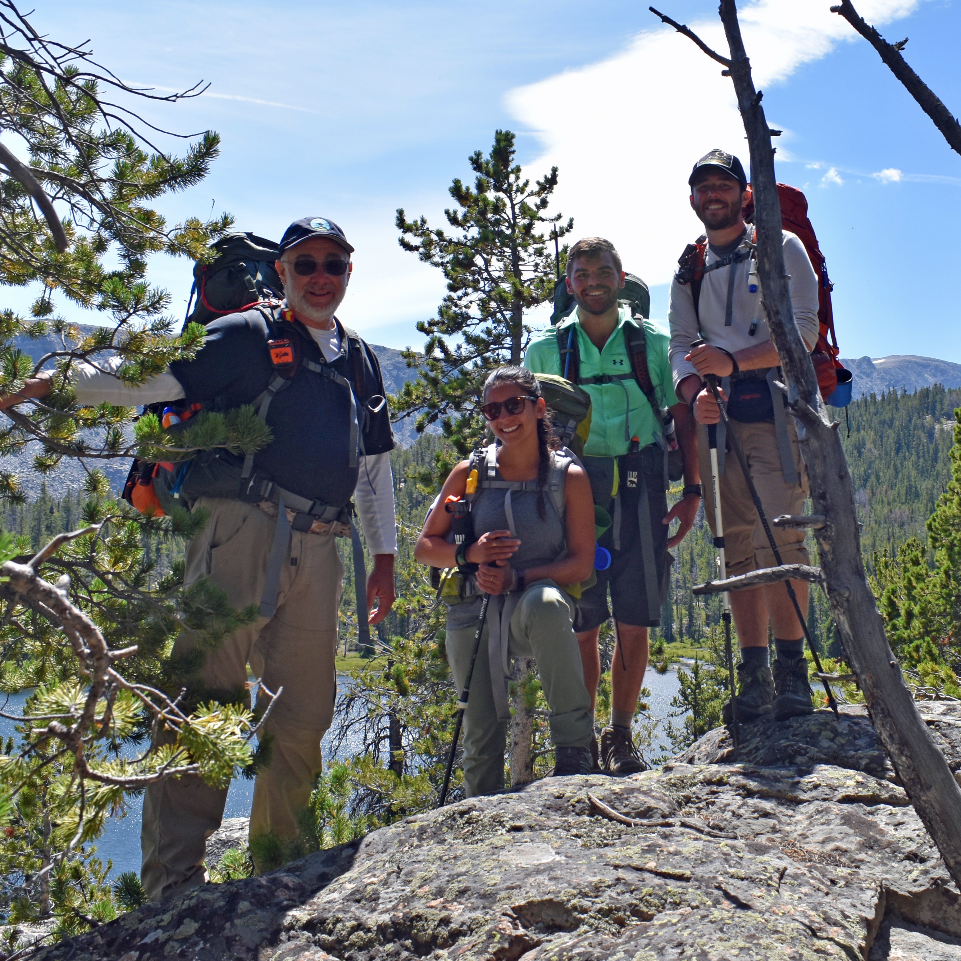
Keith, Ashley, Shawn and Dan at Moose Lake on the Dry Creek Trail.

I had planned on a very cold night last night as we were well over a 1,000 feet higher in elevation than our previous camp, but we did not have the ice and freezing temps I had expected.  We also had a pleasant break from the ever present swarms of mosquitoes we had encountered up to this point.  The sun broke on our camp earlier than yesterday as we didn’t have the peaks to the east of us which was also nice.  Our schedule called for us to go over E. Indian Pass today, but we were still several miles short of Don’s Lake, and the first three days were much harder than we had planned.  So we made the decision last night that today would be a rest and relax day with only a short hike to the next camp.  We are hoping to make up the time on Day 7 and 8.  We lounged around in camp until 10:30 am enjoying the sunshine since we knew only had a short hike ahead. Once we were packed and on our way we made the first of several navigation errors today that really set us back more than we realized at the time.  First thing in the morning Shawn took the lead and led the team over the ridge and down a long valley that headed us southeast, but we need to be heading southwest.  By the time we gathered up and discussed our error it would have been a difficult climb to regain lost elevation and get us headed in the correct direction.  So we bit the bullet and followed the valley down the hill, knowing it would intersect with the Dry Creek Trail to Don’s Lake Trail coming in from the east. The valley we were travelling down was very nice, lots of grass and shade, not too rocky and very pretty.  We followed a number of game trails and natural pathways on the way down and it was an easy descent.  We reached the trail to Don’s Lake at Moose Lake where we took a brief rest.  From there we began climbing again as we headed west towards Don’s and Cub Lakes. We reached a junction in the trail that was not indicated on our topo maps and here we made our second navigation error of the day.  We decided to follow the fork to the right as it had fresh horse droppings from outfitters and we assumed this would lead us to Cub Lake where we hoped to camp.  However this fork took us to the northeast side of Don’s lake and we had to route-find again and go cross country back towards the south and cross the outflow creek trying to get to the other side. We reached the trail again and here is where we made mistake number 3 on the day.  If we turn left here it takes us a short distance back to a nice campsite on Cub Lake.  But we turn right and follow the trail to Lake 10530 west of Don’s Lake.  A pretty spot, but the fishing was poor and it took us several miles in the wrong direction that we had to retrace the next day. Since our hiking time was short we spent the afternoon fishing and, more importantly washing our bodies and clothes.  At this point in the hike we all smelled pretty bad, especially our socks.  So we washed ourselves and our clothes and hung our clothes in tree branches to dry in the breeze.  Which worked pretty good for the most part, but our socks refused to dry.  We ended up building a fire late in the afternoon and that evening trying to use that to dry our socks the rest of the way.  Our socks smelled like campfire for the rest of the trip. Melissa did hook a nice trout late in the afternoon but lost it at the bank.  We had our hearts set on some fresh trout at this point as we were quickly losing our taste for the freeze dried food we packed in.  Unfortunately, that was our sole bite and we were skunked the rest of the afternoon.  The mosquitoes were biting though and were back with a vengeance at this campsite.  We all hit the tents and sleeping bags early tonight.

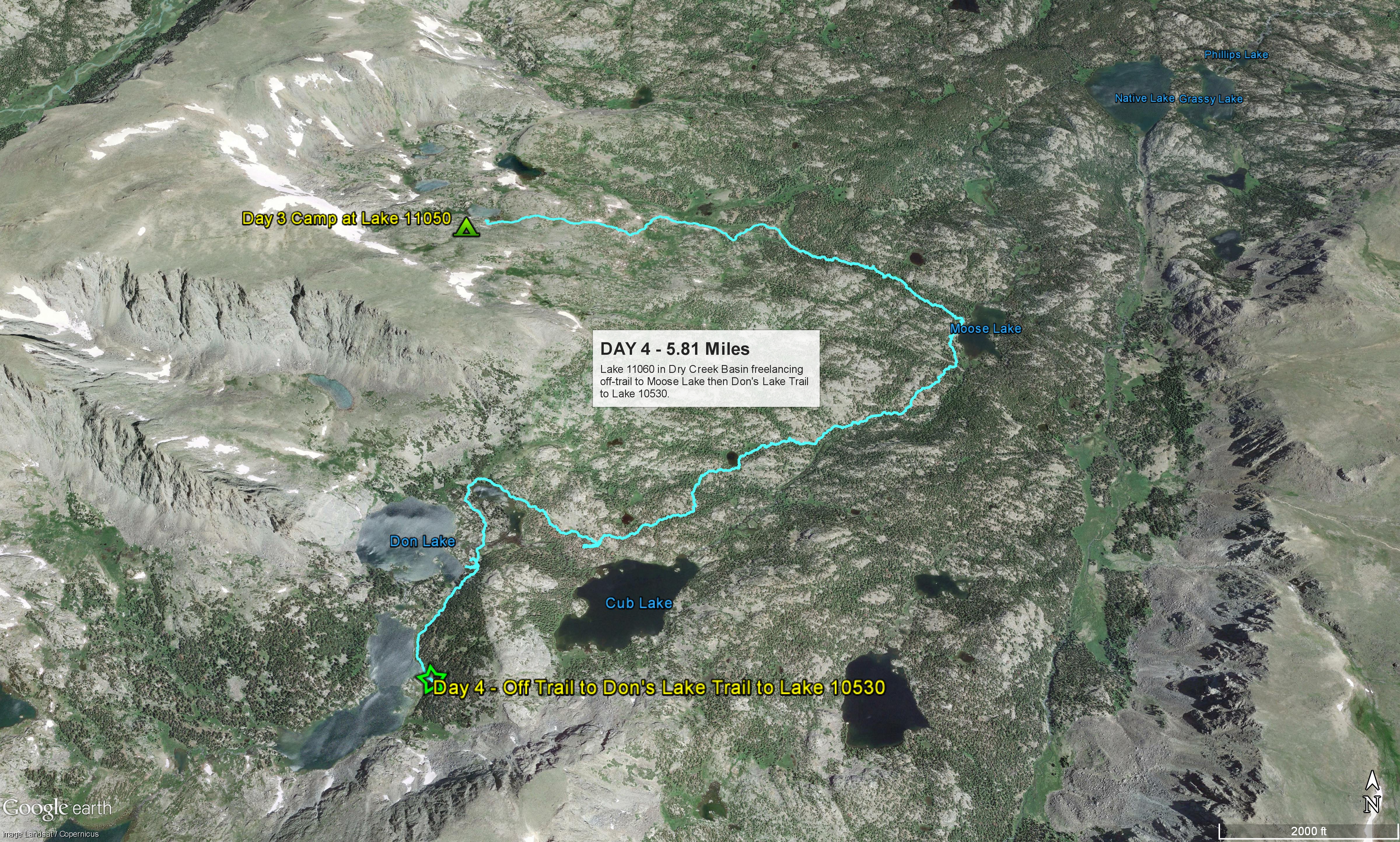
Google Earth Route of Day 4.

DAY 5 - Lake 10530 West of Don's Lake Over E. Indian Pass to Glacier Panorama

Friday, August 18, 2017 Total Miles: 9.66 Time on Trail: 9 h 38 m Beg. Elev.: 10,530 End Elev.: 10,840 Min. Elev.: 10,312 Max Elevation: 11,542

Heading up East Indian Pass.

Once again the night was cold.  Not as bad as night 2, but plenty of frost to go around.  We were on the trail by 8:00 am today, our earliest start of the trip since Day 1.  A good thing as we were on the trail for 9-1/2 hours today.  We hiked back to the east on the trail to Cub Lake covering the same mile and a half we hiked in yesterday.  Just before we reached Cub Lake we met three campers who told us they had a black bear come into their camp twice the night before after their food.  They had hung their food in the trees right by their tents, which I thought was stupid, but said nothing.  Soon after we reached Cub Lake, which was teaming with big fat trout that could be seen as we walked along the bank, and had a really nice camping spot where the sun would hit it early in the morning.  I was really upset with myself when I realized the mistakes we had made yesterday and how we could have camped here and had fresh trout for dinner and had a couple of miles less to hike today.  But the damage was done. Lessons learned for next time. We started a small climb out of Cub Lake up to the ridge above the lake.  Harder than I had anticipated, but it was over soon and we started down the hill towards Zip and Zap Lakes.  We were off-trail once again and route-finding our way.  We followed a number of game trails, and came to an area where a bear had ripped apart a hollow log where the squirrels had hidden their pine nuts inside.  I should have taken a picture.  Makes you think about what that bear could do to your camp or your tent or you when you see that.  We passed some beautiful ponds and un-named lakes and then arrived at Zip and Zap Lakes sooner than I had expected.  Before I realized it, we were at Rock Lake where we would begin the climb to East Indian Pass.  The day was going quicker than planned to this point.  We could have made it here easily yesterday and saved ourselves a lot of travel time today.  Saving that to the file for next time. From Rock Lake we began a steep climb of just under 1,000 vertical feet up to East Indian Pass.  The climb reminded me a lot of Washakie Pass last year.  Lots of rocks and boulders to pick our way around and through and over with no trail to follow.  We tried our best to stay on what grassy or tundra areas we could find but mostly lots and lots and lots or rocks and boulders with a few patches of un-melted snow.  We saw a large heard of bighorn sheep crossing the snow above us near the pass but could not get pictures because of the distance and because once they are off the snow they blend into the rocks and disappear.  Again, like last year, wild flowers are everywhere together with a strange tundra I don’t recall from last year.  It’s like a spongy green mat with tiny yellow and red flowers sprouting out of it.  After a hard climb of just under 2 hours from Rock Lake we reached E. Indian Pass and the views were incredible.  I had seen pictures by others, but this was amazing, much more impressive than I expected.  The enormous valleys on the other side are full of raging rivers, snow, glaciers and amazing peaks.  It felt like we had discovered another planet. After we rested and took pictures we started thinking about how to get down the 850 vertical feet to the lake below at 10,750 ft.  I had been warned about how steep the pass was going down, but it was more than I bargained for.  The first 50-100 feet seemed to be straight down.  Shawn took one route and I took another and once over the initial fear and intimidation we settled in.  We quickly learned to use our feet like snowboards and slide down the loose rock and gravel.  It was a long, slow and tedious descent.  Somewhere past the half way point we had to work our way over to the right through a rock field to another slide area that was not so steep and the going got a bit easier.  Once at the bottom we encountered the same problems that dogged us on Horse Ridge, rock and boulder piles, climbs that we did not anticipate, and lots of un-melted snow fields that we had to cross.  We grew very tired and were in a foul mood until we reached a huge, tundra and grass meadow at Glacier Panorama that would be our camp for the night.  It is hard to describe the beauty and total isolation we found ourselves in.  Directly across the creek were multiple peaks exceeding 13,500 ft., glaciers and an untold number of snow fields.  And yet we were totally and completely alone here with not a campfire, tent or sound of another person.  We had seen no-one since 8:30 am and only 2 groups totaling 8 people since Tuesday morning three days ago.

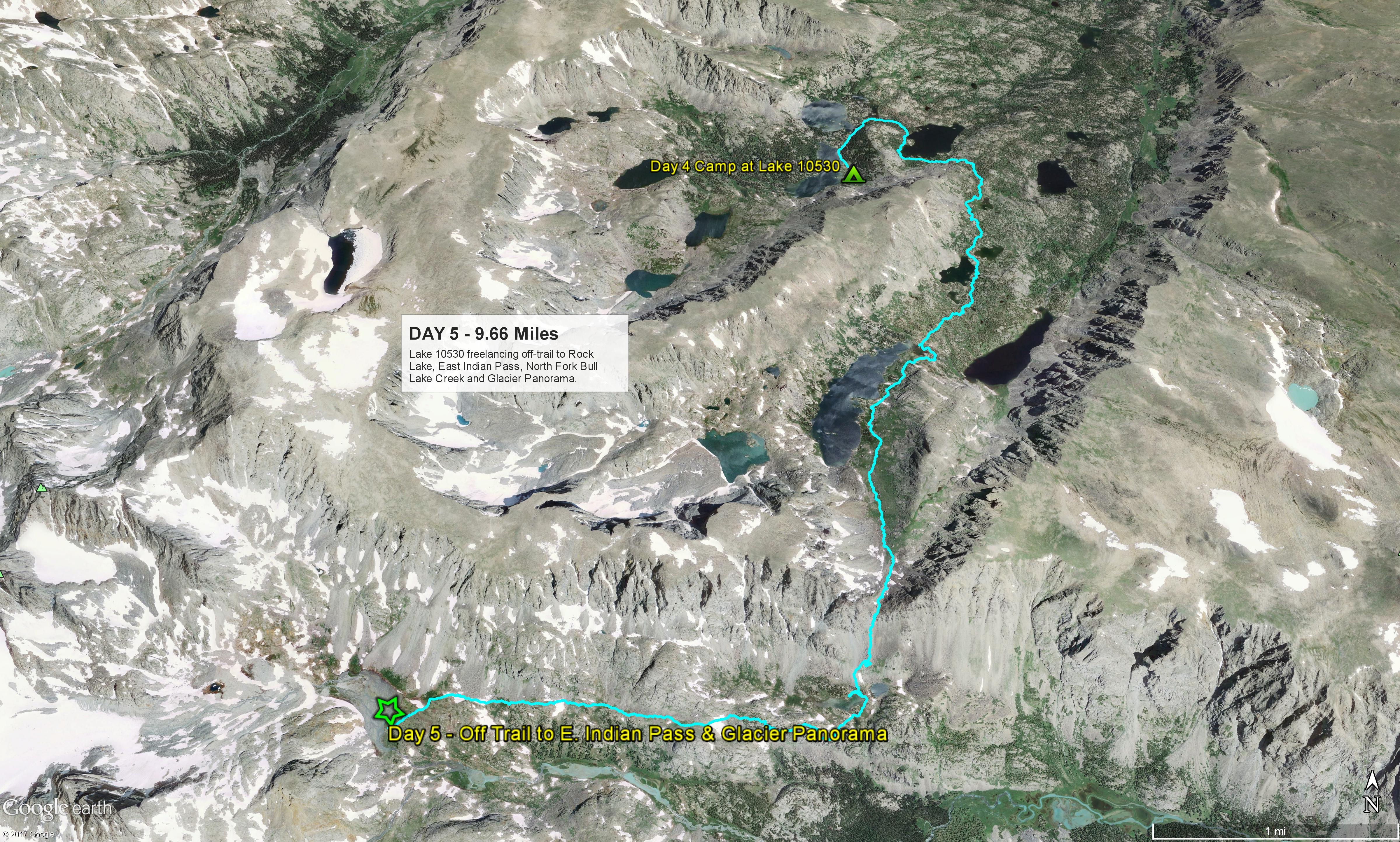
Google Earth Route of Day 5.

Day 6 - Glacier Panorama Over Knifepoint Glacier Over Indian Pass to Indian Basin

Saturday, August 19, 2017 Total Miles: 9.55 Time on Trail: 8 h 47 m Beg. Elev.: 10,840 End Elev.: 11,007 Min. Elev.: 10,512 Max Elevation: 12,133

Dan and Ashley on Knifepoint Glacier

I like the isolation we wake up to.  In this incredible place, untold acres, miles upon miles of space, and we are the only ones here.  Not a campfire, tent, or sign of another human being.  I love it.  I lay in my tent waiting for the sun to get up over the peaks to shine on us before climbing out into the cold air.  We are camped at the headwaters of the North Fork of Bull Lake Creek.  Where I am from they call this a river, here it is a creek.  It is fed by six glaciers directly to our west.  It is late August and we are surrounded by snow, 13,500 ft. peaks and a half dozen glaciers.  It doesn’t seem real.  Even better news, very few mosquitoes here to bother us. We pack up and begin hiking southeast down NFBLC looking for a place to ford.  The scenery here is amazing.  We reach a likely spot to ford but the water is high so we take off our boots and don sandals or bare feet and wade across.  My feet feel wonderful in the cold water.  Once our boots are back on we begin the climb up Panorama Pass.  On the other side of that pass is Knifepoint Creek and Knifepoint Glacier. The climb up Panorama Pass is a nice, gradual climb and then an easy run along the two lakes at the summit.  Very pretty up here and not as rocky or steep as I had feared.  The Shangri La Lakes can be seen in the valley across from us.  We reach Knifepoint Creek and begin climbing up the valley looking for a place to cross.  The creek is running high and we don’t want to risk falling in, too dangerous here.  Once we ford Knifepoint Creek we begin looking for landmarks for the correct route to Knifepoint Glacier.  I have been dreading this Knifepoint Glacier crossing since Day 1.  People that have made the crossing have convinced me we will be ok and not need crampons or micro-spikes, but they were all going down the glacier and we are going up.  And this has been an abnormally heavy snow year.  I worry more about what I may have gotten the others into than about what I have gotten myself into. There is a brief disagreement on our route up the hill.  I know the route but it is hard to match the map on my phone to the features we are seeing at times.  I have learned to keep a hard check on Shawn to keep him going in the right direction.  He is such a strong hiker he gets way out ahead of me and then we don’t realize the mistake until it’s too late.  I don’t want a repeat of the mistakes we made descending Horse Ridge and trying to reach Cub Lake.  As we climb higher we are permanently on snow for the duration to the pass.  The snow acts like a large sun reflector.  I am on snow at 11,500 ft. in shorts and a t-shirt and I am being roasted and burned.  I am coating my face and arms with sunscreen and praying for a breeze to cool me down.  Dan sticks with me as we near the glacier but Shawn heads down the hill to get off the snow. Ashley and Melissa follow him but rocks and meltwater halt their route.  They must climb out a steep section to catch back up.  A large herd of bighorn sheep crosses the glacier in front of us.  I get some pictures this time.  We spot another pair of trekkers making their way down the glacier and we pass each other at the midpoint.  From then on I walk in their steps as much as possible.  The snow on the glacier is mushy during the heat of the day but it is still slippery and the steepness and angle is increasing.  As I near the top shadows have started covering parts of the glacier and where the shadows hit the snow it freezes quickly.  I slip and fall twice, once thinking I am taking a quick slide all the way back to the bottom.  I stop my slide by jamming my trekking pole into the snow.  I rest on a rock short of the top and wait for Dan.  When he arrives Melissa is hot on his heels and she passes us both and heads for the top.  When we reach Indian Pass the exhilaration gets the better of us and we literally scream with relief. The wind is blowing hard at the top and we rest behind a wall of rocks and a boulder.  On the other side of Indian Pass we are back on trails and the hard route finding and climbing are over.  We are really tired, emotionally drained.  We search for a camp but the basin is crowded with trekkers that have come up for the eclipse.  Our solitude is over.  We end up sharing a site along the trail with a group of trekkers that will be going over Indian Pass tomorrow.

Google Earth route of Day 6.

Day 7 - Indian Basin to Titcomb Basin to Hobbs Lake on the Seneca Lake Trail

Sunday, August 20, 2017 Total Miles:12.03 Time on Trail: 7 h 58 m Beg. Elev.: 11,010 End Elev.: 10,033 Min. Elev.: 9,925 Max Elevation: 11,010

Melissa, Dan and me at Titcomb Basin.

Camping space was at a premium last night and people are on the trail at daybreak.  We have seen maybe two dozen people in total the past 6 days, and here we struggled to find a campsite and ended up sharing one with some other trekkers.  It’s a beautiful day but cold so we don’t start hiking until almost 9 am.  The trail down the hill to Titcomb Basin and Island Lake is easy to us and we make fast time. I am excited because I have dry socks for the first time in several days.  When we reach the junction to the Titcomb Basin Trail we are not prepared for the masses of people we encounter.  It seems more like a city park than the Bridger Wilderness.  People have come to see the total eclipse by the hundreds.  We drop our packs by a large boulder just off the trail and hike into Titcomb.  It is about 4 miles round trip in an out.  I am concerned about the mileage we need to make today to reach Green River Lakes tomorrow.  This adds 4 miles onto our total plus the 2 miles we are already behind.  But I promised Melissa we would see Titcomb so I don’t complain or voice my concerns. The hike into Titcomb is relatively easy and flat.  Wetter than I thought it would be, but this whole trip has been wetter than I thought it would be.  The views are spectacular.  I can see why this is considered one of the two best places to visit in the Winds, but having seen Glacier Panorama and NFBLC, Horse Ridge and both Indian Passes, I am sure it isn’t the best place we have seen.  We take our pictures and hike back out, pick up our packs and head down the trail.  Island Lake is as pretty as all the pictures I have seen.  We hike around the lake and take what we believe to be a short-cut to the Highline Trail, freelancing again to save a mile in distance.  As we approach the Highline Trail it is clear we can’t make Green River Lakes Trailhead at a reasonable hour tomorrow.  The hike will be a death march and we will stagger out just before dark.  I have decided we need to bail out to Elkhart Park but don’t break the news until we reach the Highline Trail.  When I drop the news we are bailing to Elkhart the mood picks up immediately.  The whole team is chattering again, the pace has picked up and I sense something bordering on joy.  Melissa was ready to bail to Elkhart yesterday, but even Shawn displays no disappointment.  Everyone just wants to be done now.  We have checked all the bucket list boxes and seen all the best things we came to see.  All that’s left is getting home, a shower, beer and burgers.  So I send the help message on our Spot GPS and hope Monica (my wife) can coordinate with Randy Williams in Pinedale to move our car from Green River Lakes to Elhart. The map showed what looked to be a quick shot down the hill, but even as fast as we are moving I realize that we still have a long way to go.  As we go down the hill I continue to marvel at all the people streaming up the hill as we descend and notice that so many of them have brand new, very expensive, name brand hiking gear and clothes, and boots that look like they have never been worn and brand new expensive packs that look like they are stuffed to the breaking point.  The two guys on horseback led by the outfitter are priceless, flopping around like they have never been on a horse before.  Should have gotten their picture.  As we passed Little Seneca Lake all I wanted to do was dive in for a swim.  A beautiful place and its a very hot day, for the Winds anyway.  All the lakes we pass are packed and we are worrying about finding a campsite.  We stop to talk to two Forest Service guys doing trail maintenance and they suggest Hobbs Lake for tonight’s camp.  So Hobbs it is.  Although the trail is pretty easy and mostly downhill it is still a long hike to Hobbs Lake.  I keep thinking it will be right around the next bend but there is always another bend and then another brief climb.  At least we are moving like power hikers now, no breaks on the climbs up, no stopping, just powering through it.  A good feeling, I remember this from last year. We reach Hobbs lake with several hours of daylight left.  Campsites are limited but we wedge in close to the lake on a small patch of almost flat and mostly dry ground.  We swim, wash, fish and relax away the rest of the day.  A good way to end it. We eat good and hit the hay early. Our chatter has become about burgers, beer and a shower in Pinedale. Its a good vibe.

Google Earth route of Day 7.

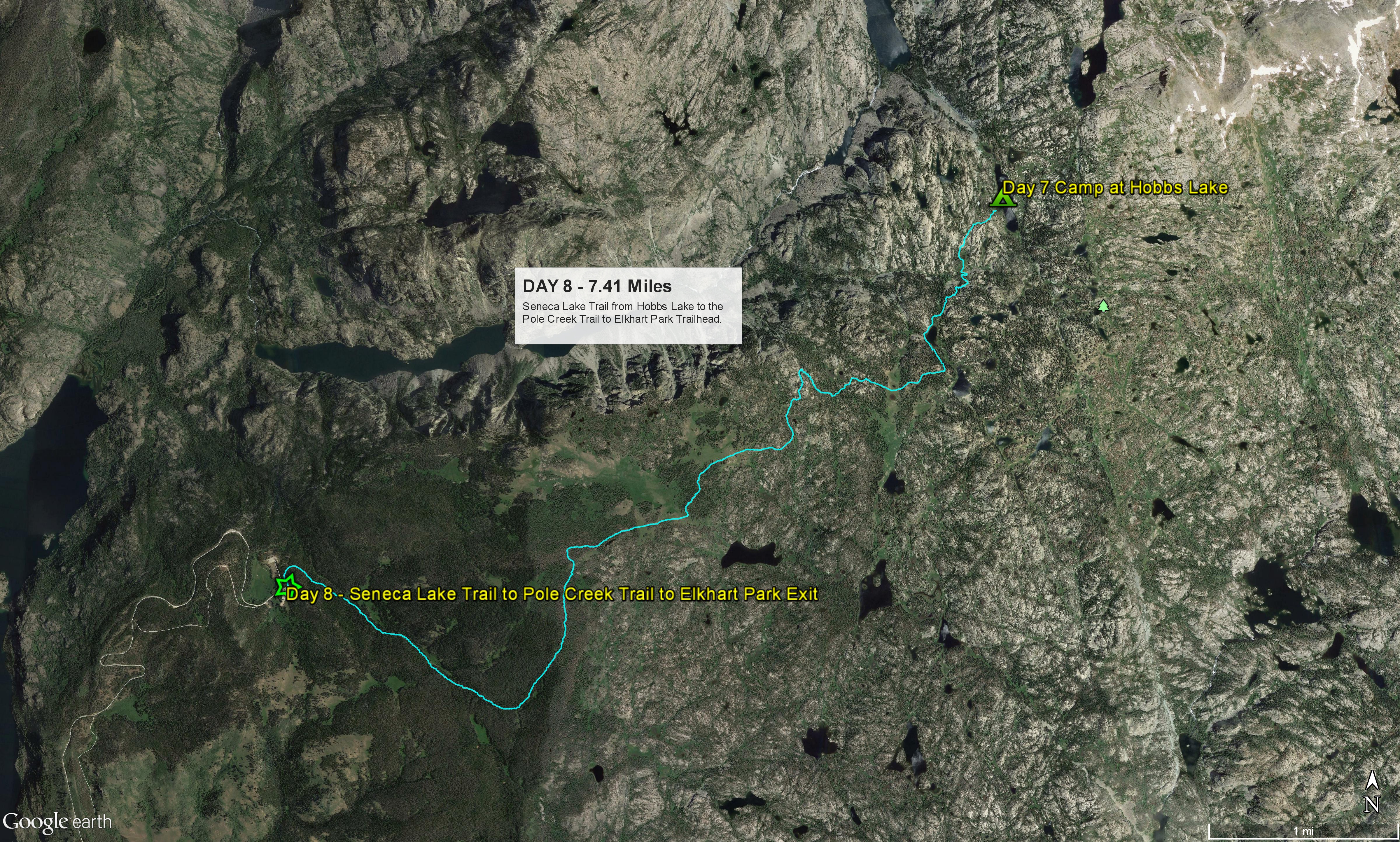
Day 8 - Hobbs Lake Via the Pole Creek Trail to Elkhart Park Trailhead

Monday, August 21, 2017 Total Miles: 7.41 Time on Trail: 3 h 2 m Beg. Elev.: 9,925 End Elev.: 9,331 Min. Elev.: 9,331 Max Elevation: 10,331

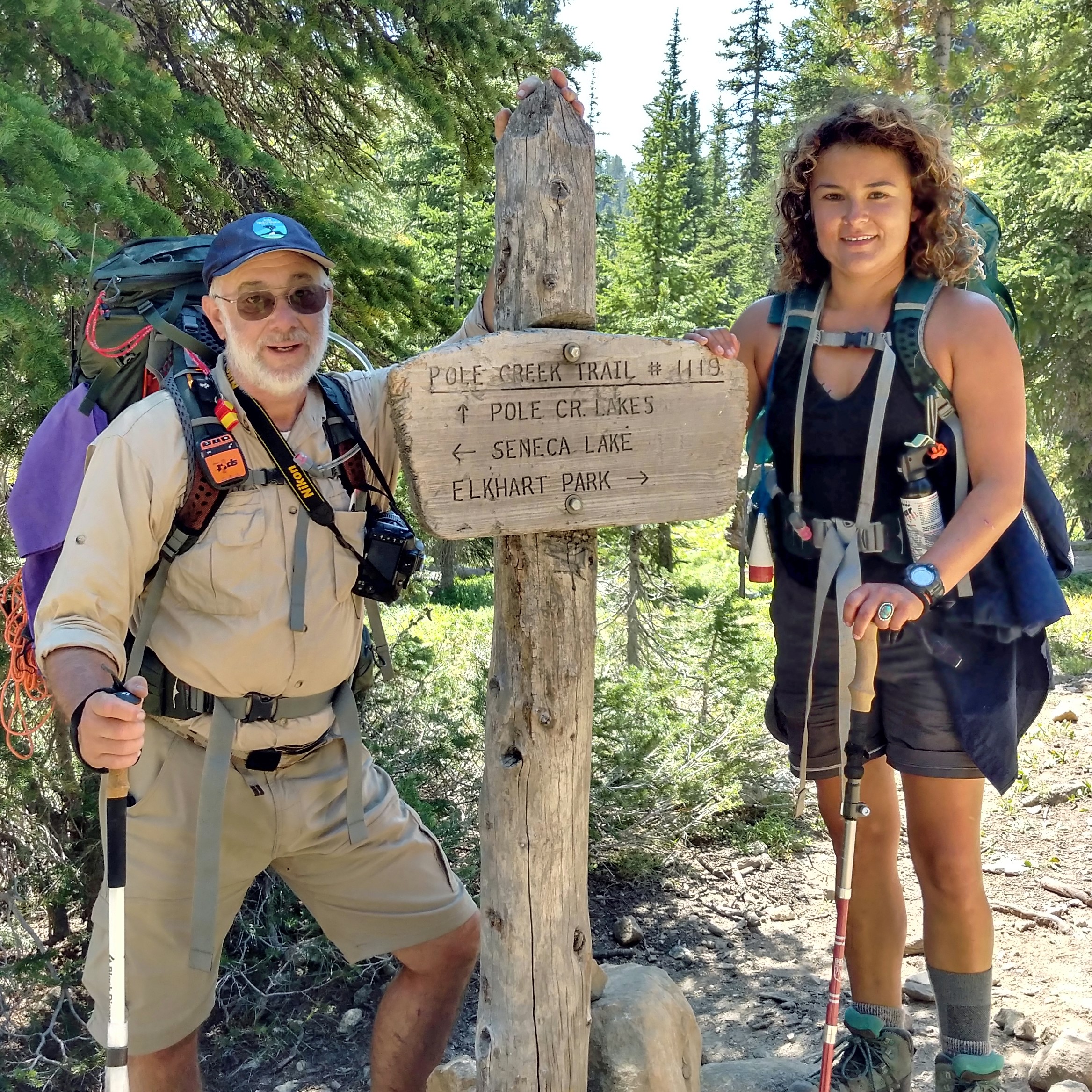
Melissa and me at the Pole Creek and Seneca Lake Trails junction.

When we wake up we find that the steady stream of people up and down the hill continues.  We are going to watch the eclipse from camp and totality doesn’t start until 11:30 am, so no rush for us.  We have a good breakfast, doctor our wounds and pack things up.  The blister on the back of Melissa’s foot refuses to heal and is bigger each day as a result of constantly wet socks and boots.  We have used up most of our bandages and all of our medical tape so we improvise.  Black duct tape replaces the medical tape and it looks like it will keep her going until we can get back to the trailhead. The morning started very cloudy and we all thought the clouds would hide the eclipse, but by 10 am it is clear and sunny.  The eclipse starts around 10:30 am.  We all have eclipse viewing glasses that we bought on our way up from Salt Lake so we relax, sit back and enjoy the show.  It is progressing much more slowly than I thought.  Even when it reaches 2/3 to 3/4 eclipse it is not really darker where we are.  But it is getting colder. As the eclipse nears totality it has gotten darker, and noticeably colder.  And then, finally, suddenly, the sun disappears and things are surreal.  While it is not pitch black, the stars and planets are definitely visible.  And the corona around the sun is incredible.  Much better than we had expected.  People on the hills and in the campsites are howling and cheering and we can’t help howling and cheering along.  And then, just like that, it’s over, and over way too soon.  It’s light again.  It takes us a bit to regroup.  Not sure how to describe what we saw and experienced.  But it was better than we thought it would be. We pull on our packs, hit the trail, and down the hill we go.  Everyone is moving fast.  We just want to be done.  The trail is downhill mostly, but we ascend to a high point briefly and Shawn’s phone gets signal.  I use his phone to call Monica.  She got ahold of Randy who will meet us at Elkhart Park, but he can’t get our car because I had him lock the spare key inside.  Duh!!  But at least we have a ride.  We can figure it our from there.  We agree we will call again at Photographers Point.  It’s about 2-hrs. from Photographers Point to the trailhead.  We reach Photographer’s Point on the trail out and take the obligatory pictures.  It is a great spot for pics, but I sense nobody cares all that much.  But I know the photos will mean a lot later on after this is over, so we get pics of everyone, make our call, and tell Monica we will be a the trailhead in an hour and 45 minutes.  And then down the hill we go again. My left foot is killing me as we descend, every rock I step on causes a sharp pain in my foot.  I need to stop and take my boot off and rest a bit, but I am thinking we are almost there so why waste time.  In the fifteen minutes it will take me to drop my pack and fix my boot and get my pack back on we could be to Elkhart.  So on we go, not stopping for anything. We cover almost 7-1/2 miles in 3 hours.  That’s really fast with 40+ pound packs and 7-days and 70-miles of hiking already under your belt.  When we reach Elkhart it’s about 2:45 pm.  Randy Williams is there and bless his soul he has cold beer, Gatorade, snacks and Redbull for us.  Randy takes us back to his house where we shower and rest for a wile while he and his Dad go to ferry our car from Green River Lakes, about a 2-hr. round trip.  His wife Cindy lends us their spare car and we go to Los Cabos, a local eatery for margaritas, beer, and food. It has been a long day and a longer adventure.  But everyone is sky high.  We did good.  This last day was an awesome way to end things.  Once we hit the hotel and changed clothes I thought the youngsters would be out ’till all hours celebrating, but everyone is in bed before 11 pm.  Except me of course.  I pass out at 9 pm and I’m wide awake again at 11 pm.  I toss and turn just like I did most nights on the trail.  Finally, since I can’t sleep, I do laundry until 3 AM.  At which point I pass out again and sleep until almost 7 am.  At least we will all have clean clothes tomorrow and won’t stink on the way down the hill to Salt Lake City airport.  Wish we had more time to relax and decompress like last year.  Oh, well, more lessons learned. But a good trip.  Success.  Victory.
Following is a recap of our gear and equipment, what we liked, what we would change and what we can recommend.  Clink on any colored link or picture for connection to a manufacturer website or Amazon current pricing.
Backpacks and Backpack Accessories
I have only owned and used one brand of backpack, Osprey.  I personally own the Atmos AG 65, a 6.5 liter backpack.  Actually I own two.  My daughter owns the women’s version, the Aura AG 65.  It is light, strong, available at a very affordable price, and ingeniously designed by someone that must spend a lot of time backpacking.  It has a main compartment for your tent and clothes and supplies, with a sub-compartment specifically for your sleeping bag.  Really smart, as you can access your sleeping bag without having to pull out everything else you packed and visa versa.  In top of that is a detachable attachment with dual-zippered compartments.  More zippered compartments are found along each side and on the waist strap.  A large stretch compartment is on the back of the pack to hold sandals, rain gear, clothing, etc.  Dual straps to hold your sleeping pad are built into the lower-rear portion of the pack.  An integrated pocket for your water bladder is inside the main compartment.  Loops, holders and straps, are integrated throughout the pack to hold things like cameras, trekking poles, Nalgene bottles, bear spray, inspect repellent, your emergency GPS device and pretty much anything else you can think of.  The pack a;lso has numerous internal adjustments to compensate for your shoulder height, torso height, hips size and the like.  We did find that the packs tend to run small compared to clothing sizes.  I am 6′-2′ and typically take a large or extra large but I found the medium pack fit best.  My daughter, at 5′-2″, took the extra-small.  A lot of people try and tell me they don’t need the 6.5 liter size, trying to sell me on the 5.0 liter or even the 4.5 liter.  I know these sizes are popular with many of the ultra-light backpackers.  But we aren’t ultra-light packers, and from experience we know for sure we can’t fit everything we need for 8-days in the wilderness into a 5 liter pack  When evaluating your backpack it isn’t really weight that is the issue, it is volume.  How much volume do you need for all your stuff?  For an 8-day trip I typically carry the tent, 80% of our food in a bear-proof container, and my clothes and sleeping bag and 3.0 liter water bladder in the main compartment.  For clothing I pack two to three pair of socks and one sock liner (depending on weather) and two of everything else (undershirt, pants, shirts).  I will pack one set of leggings and one heavy fleece or light down jacket for nights.   I have micro-towels, soap, toiletries and misc. stuff in one side pocket and our first-aid kit and some snacks in the other side pocket.  In the two top pockets I have maps, my beanie (took) and gloves, bio-wipes, snacks, cigars and instant coffee and cocoa.  Everything else is strapped on the outside.  I carry  a headlamp, an extra trekking pole, fishing pole and reel, Satellite SOS and messaging device, trowel, my camp sandals, camera, sleeping pad, solar charger, and tent stake puller/hammer on the outside of my pack.  All in with water my pack weighs in at about 45 lbs.    My daughter packs her water bladder, clothes, sleeping bag, cooking and eating gear, trash, our water purifier and 20% of our food in her main compartment.  She also packs maps and beanie and gloves, snacks, coffee and cigars in the various pockets.  On the outside she hangs and extra trekking pole, sandals or Uggs, sleeping pad, fishing pole and reel, and her rain gear.  Her pack typically weights between 28 and 40 pounds fully loaded.  Our overall rating: 5.0/5 for Quality, 5.0/5 for Functionality, and 5.0/5 for Value. [amazon_link asins=’B00MN18RLS’ template=’ProductAd’ store=’KLICompanies-20′ marketplace=’US’ link_id=’71654758-d395-11e7-8a3a-8fed61dc4a25′][amazon_link asins=’B00PZKSYCQ’ template=’ProductAd’ store=’KLICompanies-20′ marketplace=’US’ link_id=’7d730fde-d395-11e7-ba22-d5c5d749dd60′]
Boots and Footwear
This year and last year Melissa and I wore Salewa Alps Flow Mid GTX boots.  We recommend them highly.  No break in required, extremely good foot and toe protection, very comfortable, extremely durable.  The only downside we could find in them is they were not the best at keeping our feet dry.  Probably because of the vented feature along the sides which is really nice keeping your feet cool.  Salewa offers non-vented models which I suspect cure this issue.  Last year was very dry so this was not an issue.  This past summer was extremely wet, both from rain and melting snow at the higher altitudes, and we found ourselves with wet feet almost every day of the hike.  Everyone in our group suffered from this problem, and they were wearing Salomon and Keen, so I can’t lay the entire issue off on the boots.  But we will be looking at other options for next year.  Our overall rating: 4.5/5 for Quality, 4.5/5 for Functionality, and 4.0/5 for Value.  [amazon_link asins=’B00N48M986′ template=’ProductAd’ store=’KLICompanies-20′ marketplace=’US’ link_id=’c41e1e81-d397-11e7-872c-cf8de7f8adb6′][amazon_link asins=’B01HTMC91O’ template=’ProductAd’ store=’KLICompanies-20′ marketplace=’US’ link_id=’da9f88af-d397-11e7-b92d-b91b30a214aa’]             Dan wore Salomon Authentic LTR GTX boots.  The original reason for getting these boots was because it was all we could find in a size-13 Gore-Tex boot.  Despite some initial concerns, the boots performed flawlessly.  Dan suffered no foot or ankle problems or discomfort and the boots exhibited excellent water-resistance.  They also held up extremely well.  We found these boots on sale for $99.00 at Campsaver.com and have since seen them at below $80.00 (depending on size and color) on Amazon.  That is an amazingly good price point for what proved to be an excellent boot.  We highly recommend these boots for general hiking and backpacking.   For more extreme trekking or mountaineering I would suggest a step up in quality and foot support.  Our overall rating: 4.0/5 for Quality, 4.0/5 for Functionality, and 5.0/5 for Value. [amazon_link asins=’B01HD6RR18′ template=’ProductAd’ store=’KLICompanies-20′ marketplace=’US’ link_id=’fcc6f885-d397-11e7-952e-8ba0d2de0c94′][amazon_link asins=’B00SN3L64U’ template=’ProductAd’ store=’KLICompanies-20′ marketplacee=’US’ link_id=’05424ba6-d398-11e7-8600-4b1dcc89fec6′]             For 2018 we are looking seriously at the Salomon Quest 4D 2 GTX Hiking Boot based on how well Dan’s Authentic LTR GTX performed.  On the value front, the list prices are a bit high, but there have been some good deals on Amazon and other sites of late.  According to all reports these boots meld the best of trail runners with true hiking boots.  I swear by the mid-top boots for the ankle support and water resistance.  We tend to hike in places with a fair amount of mud and water and the taller boots make it much easier to keep the feet and socks dry.  We also tend to hike in places with very rocky and steep sections  and where boulder and rock hopping are common.  The added ankle and foot protection of the mid-top boots is really needed, at least for me, in conditions like this.  Not yet rated for Quality or Value. [amazon_link asins=’B00PRNQ8CE’ template=’ProductAd’ store=’KLICompanies-20′ marketplace=’US’ link_id=’24dc815c-d398-11e7-b73b-63d8c96e42cc’][amazon_link asins=’B00KWK2G5K’ template=’ProductAd’ store=’KLICompanies-20′ marketplace=’US’ link_id=’34dc1eb3-d398-11e7-858c-1d8f68dbdaf7′]             If you just refuse to wear a mid or high-top boot while trekking, and I know a lot of folks who do, then I recommend the Salewa Firetail 3 GTX Approach Shoe.  I own these shoes, as does my hiking partner Melissa, and they are outstanding shoes.  I just don’t find them practical on our more extreme and long-duration hikes.  But on a day-hike or short duration hike where I know it will be relatively dry, I love these shoes.  I use them to climb to the top of 12,633 ft. Humphries Peak in Flagstaff, AZ during the summer and they serve me extremely well.  This is a relatively steep climb with a lot of rocks and boulders, especially near the top, and these shoes offer superb traction and footing.  They also come in a non-GTX option if you don’t need the water resistance, and this will save you a few bucks, as well as a more traditional hiker optionSalomon also offers a number of good options in low-top hikers and trail runners.  Our overall rating: 4.5/5 for Quality, 5.0/5 for Functionality, and (4.0/5) for Value. [amazon_link asins=’B00N48EBC8′ template=’ProductAd’ store=’KLICompanies-20′ marketplace=’US’ link_id=’0426fbee-d399-11e7-bfa6-0314a8f2e16c’][amazon_link asins=’B011KIN05M’ template=’ProductAd’ store=’KLICompanies-20′ marketplace=’US’ link_id=’e7e84cf6-d398-11e7-9aaf-df3e14ac4211′]             For socks I highly recommend the Lorpen brand and specifically the Lorpen T3 Hiker Sock.  These socks have proven themselves on multiple hikes and I swear by them.  They keep your feet dry, insulate really well, and are extremely durable.  Most importantly for me, they offer superior cushioning and comfort to my feet.  I always recommend going with thicker socks over thinner socks, even in hotter weather, purely for the foot protection and comfort factor.  I have tried altering my sock thickness and whenever I wear the thinner socks my feet hurt more.  Thicker socks can also handle more water, either from wicking up perspiration or from water infiltration into your boots.  If things get colder, or if I need additional protection on wet and muddy trails, I will wear a thin liner sock underneath my main sock.  I find the liner sock to really help when I know my feet will be getting wet, like this past year when we were crossing a lot of mushy snow fields or trails that were soacked from rain and melting snow. Our overall rating: 5.0/5 for Quality, 5.0/5 for Functionality, and 5.0/5 for Value. [amazon_link asins=’B01M04ZXBS’ template=’ProductAd’ store=’KLICompanies-20′ marketplace=’US’ link_id=’1cb3ed44-d399-11e7-aa75-e523e22aec5d’][amazon_link asins=’B01MQE6QXP’ template=’ProductAd’ store=’KLICompanies-20′ marketplace=’US’ link_id=’365cfce8-d399-11e7-9af4-077f27634f98′][amazon_link asins=’B00JRD1S7U’ template=’ProductAd’ store=’KLICompanies-20′ marketplace=’US’ link_id=’5c75a4b7-d399-11e7-8dea-45986da46628′]                      

Ozark Trail Sandal

Finally, we can’t forget sandals for nights in camp, fording creeks and rivers and generally getting out of our boots at the end of a long day.  My criteria for camp shoes is 1) they must be very light, 2) they must be easy to pack, 3) they must have straps to keep them on your feet (no flip flops or slip-on’s for water crossings), 4) they must be cheap (inexpensive), and they must dry quickly.  I bought mine this year at Walmart and paid $10.00 for the pair.  I was also able to get them in a size 13 for Dan.  We liked them so much we wear them all over, not just on our hikes.  If there is a downside to these sandals, it is having no covered toe.  But that is about it.  They are super light and super comfy and I was able to strap them on top of my air mattress on the back of my pack, protecting it when I put my pack down and taking up no extra space.  They don’t absorb water so there is no drying time. The quality isn’t great and you wont be wearing the same pair for 3 years, but for $10 bucks, who cares.  Our overall rating: 3.0/5 for Quality, 4.0/5 for Functionality, and 5.0/5 for Value.      
Water Purification
Water purification is critically important to us.  We don’t want to EVER get sick from bad water.  But there are other practical concerns beyond just clean water when considering a system or product.  For example, how long does the process take and for how much water?  Can I use water out of shallow or muddy ponds or streams?  How reliable is it?  How easy is it to clean and repair?  And finally, how much does it weigh and how much room does it take?  Any system or  product that you choose needs to address these issues? [amazon_link asins=’B000BBF2RY’ template=’ProductAd’ store=’KLICompanies-20′ marketplace=’US’ link_id=’1f07caed-d39d-11e7-815b-7184b6723bba’] Last year Melissa and I used the MSR MiniWorks EX Microfilter. It is an old-school solution that is rock-solid reliable and can be used where minimal water depth is available. Your Nalgene bottle or water bladder can attach directly to the bottom of the filter tube and it is easy to deploy and get operating in short order for quick refills mid-trail. The filter itself, which is actually a ceramic cartridge, is easy to remove and clean. It is packs down relatively small and, while it’s not as light as some other options, it isn’t real heavy either. It is an excellent solution for one or two hikers in almost all conditions and we found ours to be virtually indestructible. The downside of this filter is the time it takes to operate. It’s SLOW. We spent way too much time pumping the handle of this thing. We both had 3-liter bladders for our backpacks and it took a long time to fill both bladders. Water for cooking and spare water for our Nalgene bottles added even more time. For multi-day treks with a lot of cooking or the need to make clean water for more than one or two people, this is a very poor option. Our overall rating: 4.5/5 for Quality, 3.5/5 for Functionality, and 3.5/5 for Value.   [amazon_link asins=’B01MYXVV4X’ template=’ProductAd’ store=’KLICompanies-20′ marketplace=’US’ link_id=’3cf6e90a-d39d-11e7-92cf-534c5b5c06df’] For this year’s hike we wanted something that could process significantly more water in a short period of time.  We selected the MSR AutoFlow Gravity Filter with a 4.0 liter bag.  It is light weight, didn’t take any more space than last year’s MicroFilter, and could be hung from a tree or our trekking poles to fill while we went about doing other things.  It served us well and was able to do the bulk water purification we required for five hikers on this year’s trek.  The unit does come with some drawbacks that should be considered.  First, it is difficult to fill the bag in very shallow water without scraping up mud or debris inside the bag, so if you will encounter those conditions, select another option.  Second, although it has a pre-filter inside the bag, it will clog very quickly in murky or muddy water conditions and the filter cannot be cleaned like the MiniWorks filter can.  The filter must be back-flushed each time it is used, even in relatively clear water.  Third, it was not effective to deploy quickly mid-trail to fill a Nalgene bottle or grab a quick drink. Finally, the unit proved to be a bit finicky and it was imperative to clear the lines of bubbles, get the routing of the tubing to the bottle or bladder just right, and make sure the filter was back-flushed properly and often, or the flow would slow to a trickle.  Our overall rating: 4.0/5 for Quality, 3.5/5 for Functionality and 4.5/5 for Value. [amazon_link asins=’B00187CZ0W’ template=’ProductAd’ store=’KLICompanies-20′ marketplace=’US’ link_id=’af45258f-d39d-11e7-8954-4bb6ebcb27c4′]MSR has come out with two new products this year that we will be looking at closely.  The first is the HyperFlow Microfilter which seems to blend the best of the MiniWorks EX filter with the AutoFlow Gravity Filter.  It operates with a pump type system, can be used effectively in shallow water conditions, and offers a flow rate of 3 liters per minute.  It is also offered at an astoundingly low price.  I prefer the utility of the gravity system and not having to sit and push a pump every time we want water, but the gravity system proved to be less idiot proof than we had hoped and has a filtration rate half of the HyperFlow.  I suspect that it will have the same drawbacks as the AutoFlow Gravity filter as far as clogging and difficulty cleaning the filter.  But it sounds like a great option if it works as advertised. [amazon_link asins=’B01N7GC9Z6′ template=’ProductAd’ store=’KLICompanies-20′ marketplace=’US’ link_id=’bde50b2a-d39d-11e7-80f6-1506ca1b7ae4′]The second is the TrailShot Pocket Sized Filter.  This one has me really excited.  Often, when we are out on the trail, we run out of water in our bladders but don’t really want to stop and spend the time dropping our packs, pulling out the bladders, filling the bladder and putting it all back together again.  We just want to grab a quick drink and put a little water in our Nalgene bottle.  The TrailShot seems to offer up that ability.  From the looks of it, it will stow in a small pocket and can be pulled out without dropping our packs and put directly into the water source for a quick, drinking fountain-like drink or a quick fill of a water bottle.  
Tents, Sleeping Bags, Sleeping Pads and Related
[amazon_link asins=’B00G7H9CAY’ template=’ProductAd’ store=’KLICompanies-20′ marketplace=’US’ link_id=’675d2322-d39e-11e7-8eeb-17bca0f8eff9′]There are a lot of really good tents on the market.  They are getting lighter every year.  There are also some really bad tents on the market, and a lot of really expensive tents that are only marginally better (lighter) than some other less expensive tents.  I base my evaluation of a tent on weight, durability, performance and price.  It doesn’t have to be the lightest tent out there, but it should be in the 3 pound range all in, stakes, tent, rainfly, storage sack and footprint. 4-1/4 lbs. at the max.  As tents get lighter, they use thinner materials and they get less study.  If the tent breaks down, it is a worthless. And it has to perform.  By that I mean wind and rain performance, bug resistance, access into and out of, lack of water condensation.  I am sold on MSR and have purchased the MSR Hubba-Hubba NX 2-person tent twice.  It weighs in at 3 lbs. 7-oz and packs down very compactly.  Our Hubba-Hubba has endured winds, rain, and hail on multiple, multi-day hikes and never let us down.  It has never leaked, and can be self-repaired easily if needed.  It is also 100% mosquito resistant, which is a necessity for us when we are in the Winds during the summer.  It has two entrances, one on each side of the tent, so you or your partner are not crawling over each other as you go in an out or when you have to get up and pee in the night.  The rain fly eaves provide plenty of room to store your pack and boots under at night so they don’t get wet.  And the ability to pack just the tent frame and the rain fly as a quick shelter or bivy is a great design option.  I do this a lot during summer day hikes.  It saves several pounds of weight and I can quickly deploy it whenever rain or lighting forces me into shelter.  It is also a great overall value for the money.  There are other tents that are much more fragile, cost hundreds more, and you only save a pound.  If you aren’t an ultra-light hiker looking for any weight savings you can get, it’s just not worth it.  I purchased both of mine from ebay sellers which saved me a lot of money.  One had some small holes from cigarette burns which I repaired easily following the manufacturer’s directions.  You can’t even see the holes.  The other looked to have never been used.  We did have a tent frame pole break one time.  We used the included repair kit to temporarily get us through and the manufacturer replaced it with no questions asked when we submitted it for warranty.  Finally, and this is purely personal preference, I always get a 2-person tent.  I can’t afford multiple tents for all occasions, so for me a 2-person tent is the only smart option.  A 1-person tent is very limiting.  If you camp with another person you both have to pack tents, and one 2-person tent is lighter than two really light 1-person tents, not to mention the added pack volume of two tents.  And even if I am out alone, its just one pound more than a 1-person tent and I have room to put my pack inside with me.  Our overall rating: 5.0/5 for Quality, 5.0/5 for Functionality, and 5.0/5 for Value. [amazon_link asins=’B01AYPQJQY’ template=’ProductAd’ store=’KLICompanies-20′ marketplace=’US’ link_id=’82713459-d39e-11e7-b514-83b12d219a02′] I have tried a number of sleeping pads.  For the best nights sleep and best comfort Big Agnes has won hands down.  My current sleeping pad is the Big Agnes Air Core Ultra.  I originally purchased a Big Agnes Double Z, which was the most comfortable pad I have ever slept on.  But it developed a leak after 4 nights in the wilderness, and each time I fixed a leak it sprung another.  I sent it back to Big Agnes for warranty evaluation and they replaced it with their newest pad which is the Air Core Ultra.  I also got the wide and long (25″x78″) version.  Although not quite as comfortable as my old pad, it is a clearly superior in every other way.  It is very easy to inflate and has a separate deflation valve for quick packing.  It packs up very, very small and light, about half the packed diameter of our ThermaRest pads.  This past year I suffered no leaks or problems and my pad was the envy of everyone else on our hike.  Overall cost is similar to other pads of the same quality level but more expensive than many lesser quality pads, or pads that are significantly larger and heavier when packed down.  I find the air mattress pads to be significantly more comfortable than any of the closed-cell foam options and they pack down so much smaller than the foam.  For me, the minimal added inflation time is not a drawback, and I use the good old-fashioned lung inflation method and not a pump.  Our overall rating: 5.0/5 for Quality, 5.0/5 for Functionality, and 5.0/5 for Value. [amazon_link asins=’B00DDP3DZ8′ template=’ProductAd’ store=’KLICompanies-20′ marketplace=’US’ link_id=’9ba38d84-d39e-11e7-b8ec-0d573b11f6f0′] My criteria for selecting my sleeping bag was simple.  Pick the bag that cost the least while providing a specific performance rating at a weight not to be exceed.  My matrix led me to the Teton Sports Tracker +5.  It is a heavier bag at 4 lbs., but it has a 5 degree above freezing survivability rating and a price point that is the lowest of any similarly rated and bag in its class.  I have purchased mine all on Amazon and have yet to pay more than $80.00 for any of them.  The construction is excellent and we have had no breakdowns or problems in any of the three Teton Sports Tracker bags that we own.  I also get the long option which adds 4″ to the overall length.  Similar bags from Mountain Hardware, Alps, or Big Agnes generally run two, three or even four times this cost, but they can run from 1 to 2 lbs. lighter, which if you can grab the bag in the $150-$175 range makes sense, otherwise, it is not worth it, at least to me.  I have also tried the +20 degree option but found that on very cold nights (32 degrees or below) I was not comfortable.  Not freezing or miserable, but I needed to wear my fleece and pants to bed to be warm enough.  If temps below 32 degrees are not an issue for you then you can save a couple bucks and a pound of weight by going to the +20 version.  Our overall rating: 4.0/5 for Quality, 4.0/5 for Functionality, and 5.0/5 for Value. [amazon_link asins=’B01N4BRE8M’ template=’ProductAd’ store=’KLICompanies-20′ marketplace=’US’ link_id=’e80e161e-d39e-11e7-b442-2946b4ea323e’] My final sleeping option is my inflatable pillow.  They now make inflatable pillows that pack down to almost nothing.  My personal Favorite is the Reehut Ultralight Camping Pillow.  It’s only 4×2.6 inches when packed and inflates to 19x11x4 inches.  It only weighs 2.8oz and it inflates and deflates in seconds.  I especially like this one because it has a special surface coating that is almost fuzzy, so it doesn’t feel like slick or cold plastic.  And it is a fill valve with a push button in the center.  Push once and air won’t come out as you blow air in, push again and all the air rushes out for easy compression and packing.  You can vary how much air you put in to make it firmer or softer.  Even better yet, it sells for under $10 bucks.  Our overall rating: 4.0/5 for Quality, 5.0/5 for Functionality, and 5.0/5 for Value.
Electronics and Cameras
Clothing